
Britain From Above – Beautiful Use of Satellite Technology | FlowingData
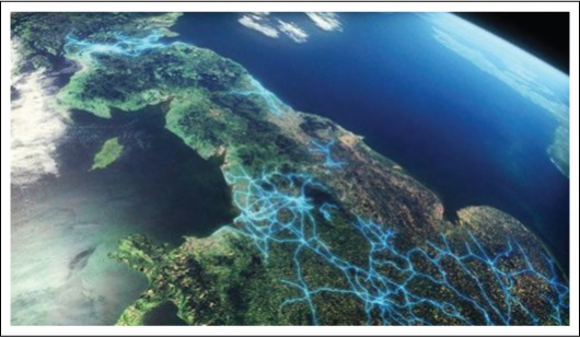
The BBC has a gorgeous documentary series that started yesterday — Britain from Above. They take a look at Britain from the skies using satellite technology and GPS data. Watch patterns emerge as taxis, ships, and planes travel back and forth and information and data pass through Britain’s national telephone network.


They should have mapped all the BT telephone exchanges and copper wires with 8mb download speeds coming to life across 24 hours. They could name it “24 hours of darkness”.
Are these geotagged, GPS logs mapped out, or just animation?
uhm are ya sure this isnt from an episode of dr who or torchwood?
just a special effects clip showing the rift under cardiff seeping residual energy out of it??
Mapped second by second, indeed. And coming soon, recorded second by second.
Well it was produced by the BBC. They took the raw data to make it look like that. I’m sure it’s the same effects crew used for Doctor Who/Torchwood/Sarah Jane Adventures.
You have good tastes in TV shows admfubar. Can’t wait for the Xmas special.
They make it look neat and all. But what most of you are missing is the tools that will someday be put to use by an oppresive system. These tools that make life easier will also make it much easier for them to track anyone for any reason.
I wonder how Bush and company use this same information.
Using satellite 3d maps and topo maps I believe I have found our dinosaur killer. Actually an old atlas will let you see it too. The use of maps.live and google 3d has aided me in confirming secondary impacts.
Off topic slightly but “Beautiful Use of Satellite Technology” seemed appropriate.
Anyone interested, look at North east Oregon. The crater is from ‘Nearly’ Portland Or. to Bozeman Montana. Nevada looks much like an ejecta blanket from many Martian craters especially Tycho. Also look up a map of ‘The Columbia River Basin’ All rivers flow to Wallowa (near enough all)
Use the maps (especially google topo with the distance measuring tool)to see Loon lake in Montana on highway #2. Start the tool at just North of Enterprise Oregon. This is one of very many secondary impacts. I consider Vermiculite Mountain to also be one (yes the infamous one near Libby Mt).
The crack that runs from it to Yellowstone park containing the Salmon river. The emptying of Lake Missoula perhaps? All the hot springs and so on.
Its so obvious, was it just too big for anyone to think it was an impact site?
Anyhow I have enjoyed satellite tech 🙂
-Dennis-
Very cool.