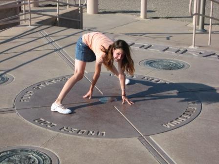
The Four Corners, a famous and popular tourist spot in the American Southwest, is and isn’t where it should be. Confused? Read on.
Four Corners — the only place in the United States where four state boundaries come together — was first surveyed by the U.S. government in 1868, during the initial survey of Colorado’s southern boundary line. Its intended location was an even 109 degrees west longitude and 37 degrees north latitude. However, due to surveying errors, it didn’t come out that way.
According to readings by the National Geodetic Survey, today’s official marker sits at 109 02 42.62019 W longitude and 36 59 56.31532 N latitude. That means the current monument marking the intersection of Utah, Colorado, New Mexico and Arizona is approximately 2.5 miles west of where it should be. According to three different Internet sites for distance calculations (including an FCC site and GPS visualizer) the readings were 2.493; 2.484; and 2.499 miles. A member of the Utah Association of Geocachers in Price also came up with 2.5 miles by using two other Internet sites, Google Earth and the Great Circle Calculator. (Geocachers routinely rely on GPS data to find exact locations.) The true location would be downhill to the east of U.S. 160 in Colorado and northeast of the San Juan River as it flows into New Mexico.
Four Corners Monument is open year-round, 8 a.m. to 5 p.m., except Thanksgiving, Christmas and New Year’s Day. Entrance fee is $3 per person.
But what’s a couple of miles between states?


OOPS!
So if i’m “carrying” when i walk around the four corners monument – i’m not guilty of interstate trafficking?
I read a book recently that was all about how the States got their shapes. Surveyor errors were very common. Some of those disputes have lasted into the modern era. Wasn’t it in the 1990’s that New Jersey won a case in which they claimed that the land around Ellis Island is actually NJ and not NY because the original deal was that everything under the water at that point was NJ and just because NY built up the island, that area was still officially NJ?
How the States Got Their Shape
By Mark Stein
http://tinyurl.com/czk9t5
No problem, until something of value is discovered in one state that is actually in another. Then the fur will fly. Hoe it happens soon. Should be entertaining.
#5. Nothing but sand, coyotes, and prarie dogs. Oh and rattlers.
So now everyone that went there and took photos for keepsakes will now have to throw them away… they’re useless.
Easily fixed, just redraw the statelines. problem solved! 🙂
Survey was very difficult, especially in the frontier, in the 19th and early 20th centuries. Survey errors are very common. That’s why in most places, the law is that the official survey exists only on the ground and can only be officially defined by a licensed land surveyor.
Close enough for Government work. . .
I suppose the orgional error on the survey was +/- 2.5 miles. Oh well, its close.
Since the onset of the drought in the Southeast last year, Georgia has been fighting with Tennessee to move its border 1.1 miles north so that it will have access to the Tennessee River and its water.
http://abcnews.go.com/GMA/story?id=4269092
So your saying that the picture of my mother sitting in the center of that circle, doesn’t prove she has a butt big enough, to cover four states?
Dang nabit!
Actually, the state lines were eventually adjusted to fit the marker. The border between Utah and Colorado, and between Arizona and New Mexico is set at 109 02 42.62019 W, rather than 109 W.
Trivia question: What President of the US is responsible for creating the borders so that the four corners would match up?
A: Abraham Lincoln – one of his less famous actions.
Actually, it is easy to understand how they got the latitude nearly perfect, but the longitude off. by a few miles.
Before accurate tools, latitude and longitude was determined by protractor, sundial, magnetic compass, and a book of charts of the suns position.
Latitude, requires getting the date right, Longitude requires getting the time right too.
Since gps has become commonplace tons of surveying errors have shown up. Moreover, some of the original deeds to things were woefully vague with some deeds saying the the property was “a hundred yards from the stump on old man Smith’s farm” or something like that.
“FOUR STATES – HERE MEET – IN FREDOM – UNDER GOD”
Ah, I see the problem now… intelligent design.
Now comes the class action lawsuit for false advertising and fraud. Gonna refund all those $3 fees which, after the lawyers take their cuts, will be about a buck and a quarter.
4th down… One to go
oops thought this was a “Caption this photo”
#5, McCollough, you forgot the great dark skies with no light or air pollution.
Hellooooo Kitt Peak, Sac Peak, etc.
I want my $3 back. With 7% interest. Compounded. Today valued at $12. Charlatains!
“The true location would be downhill to the east of U.S. 160 in Colorado and northeast of the San Juan River as it flows into New Mexico.”
There’s probably either a Walmart on that spot. Or a Starbucks. So good luck getting them to give it up for $3 a head. I wonder how that would effect determining state’s sales tax, if a retail business did sit on the four corners spot? They’d probably move the cashier lines to which ever “corner” had the highest sales tax. And they only pay back the lowest tax.
Just like how drive in fast food joints charge a sales tax. Though you can’t eat on their premises (except the parking lot). And they pocket the taxes they collect. At once time (long ago) I use to eat at Roy Rogers, and request not to be taxed for my takeout order. And they DIDN’T tax me! But I tried the same thing with Wendy’s, later on. And forget it, they always apply the sales tax. Wendy’s corporate management has their employees well trained to ignore the law. Or maybe they lobbied to close the sales tax loophole. Anyone here, know for sure? Is every retail establishment pocketing the sales taxes on prepared food?
As several have pointed out, early surveying was often rife with errors.
One easy to see result is when a straight road suddenly makes a jog at an intersection. The old surveyors used chains to measure off distances. Two surveyor’s chains might be off by one half inch, but that half inch repeated many times added up to several feet.
Another instance would be traveling from one county to another where none of the cross roads match. They were surveyed from different starting points with no regard for neighboring surveys.
As a tourist spot, does it really matter? It’s fun to be there and makes you think about how much space there is for us to enjoy. All the history and error making just adds to the significance of this place.
Even as a twelve year old girl, I find it interesting that they made surveying mistakes and that it is marked 2.5 miles off of where it really should be. I sometimes question myself if they made the mistake on accident, or on purpose. But, then again, I am an American citizen and I admit it is on my bucket list so therefore I will probably still visit the “fake” 4 corners as well as attempt to find where the spot really should be.